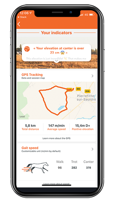
In the Equisense App you have the possibility to track your ride on a GPS map. This adds to all the indicators from your Motion and Motion S sensor your
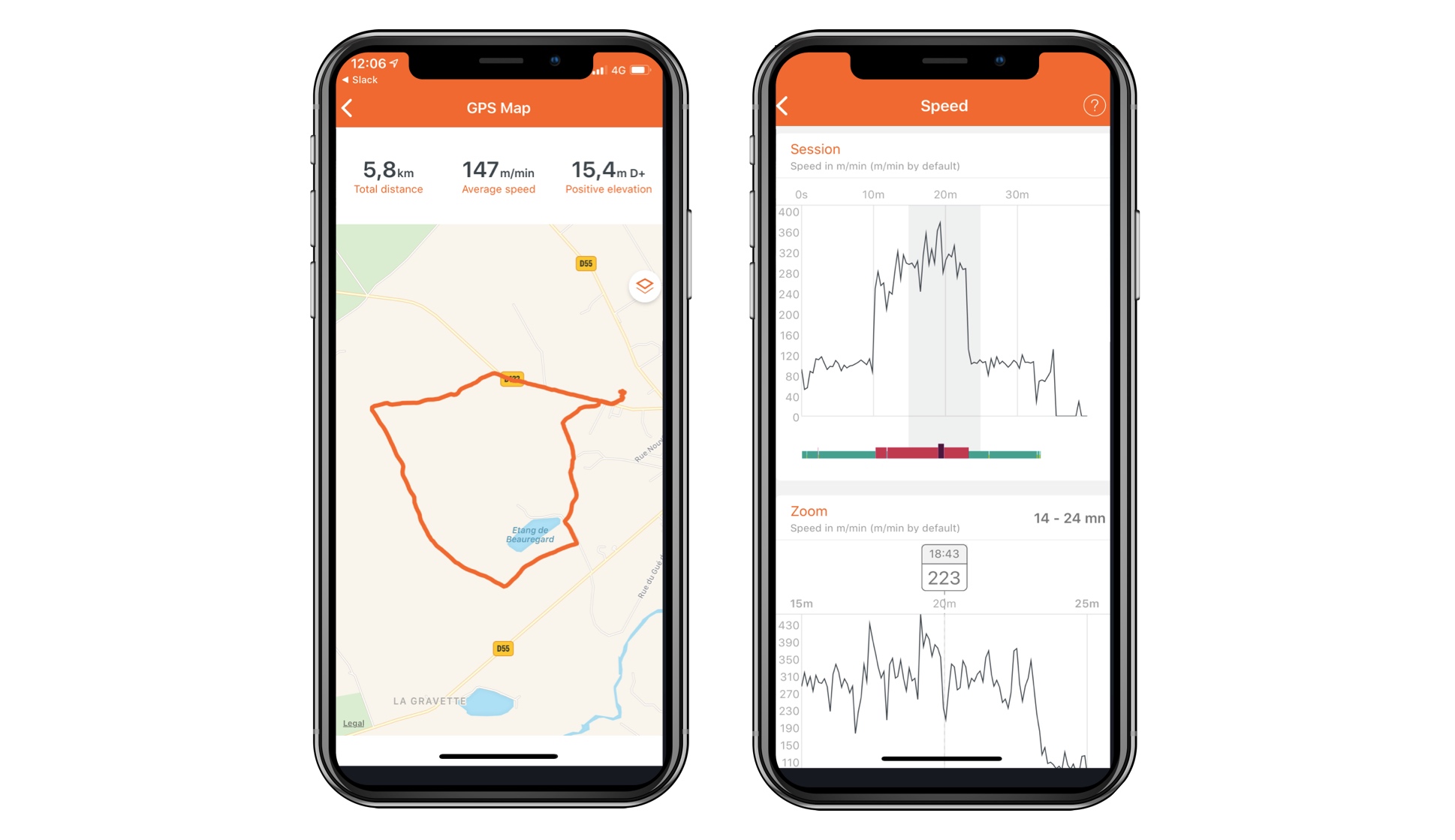
total distance
average speed
track of your ride
elevation
speed per gait
The GPS tracking is also available for users without sensor. It takes the GPS from your smartphone.
Which indicators are measured?
Total distance
It's the accumulated distance that you covered during the session.
Average speed
The average speed tells you at how which speed in km/h, mph or m/min you have been on average throughout your entire ride! The default unit is meters per min (m/min). This indicators gives you an idea on how intense the ride was for your horse and helps you measure the fitness of your horse, especially in combination with the heart-rate monitoring. It is a very powerful tool for endurance riders!
Speed per gait
The information speed per gait gives you a more detailed view of the speed during your ride. You can see at which speed you have been at which moment of your training.This has 2 major advantages: helping you to rebuild specific moments of your hack in a precise manner and helping you to do interval training in the most effective way. This indicators is even more valuable when combined with the heart-rate monitoring and recovery time! Use your Motion or Motion S sensor to get the speed per gait. In order to give you an idea, here are a few speed cues: At walk: 70-100 m/min (4.5 - 6.5 km/h ou 2.6 - 4 miles/h) At trot: 150-350 m/min (9 - 21 km/h ou 5.5 - 13 miles/h) At canter while jumping: 350 m/min (21 km/h or 13 miles/h) At canter on a cross country course: 500 m/min (30 km/h or 18.6 miles/h) A trotter in a race: 850 m/min (51 km/h or 31 miles/h) A canter horse in a race: 1200 m/min (72 km/h or 45 miles/h)
Your ride on a map
The app represents on a map the entirety of the points caught by the GPS. You've find a nice hacking path you absolutely don't want to forget? Good that you've recorded with in the app! Now, you can do it over and over again! Furthermore, you can see your track appear in different colors, showing you the gait you have been at these exact moments of your hack!
Positive elevation
Here, we're calculating the total vertical gain. This means we're going to add every ascent you did, and we're going to calculate the difference between the lowest point and the highest. The higher the positive elevation, the more you ascended, the harder it is for the horse! Be careful however, we only count the elevation if it's above 10m between both points. We use tiers to avoid inaccuracy. If you went over a 1m high mound, it won't be taken into account.
In order to display the GPS tracking on a map in the app, we use the GPS of your device (phone or tablet). To be able to do so these 3 conditions have to be met:
Keep your device with you while riding
In order to track your ride, you have to keep your phone with you while riding as we use the GPS signal of your phone.
Switch on the localization of your phone
Without an active localization service of your phone, we cannot localize you, hence, not display any data on your whereabouts. If asked, choose "always" for the localization.
Make sure energy-saving mode does not shut down the GPS
In order to save energy, it is possible that you might have switched on the energy-saving mode of your device. Make sure this energy-saving mode does not shut down the GPS tracking when going into standby mode after a few minutes. If asked, choose "always" for the localization.
How precise is the GPS tracking?
GPS is a system which is based on the position of different satellites which pass around the Earth. The satellites calculate your position at more or less regular intervals and send it back to the application. This system poses several limits:
The GPS signal is very difficult to pass through a roof, especially the roof of a riding school. Its use is therefore not recommended in this case.
The accuracy is often> 5m. This means that the GPS only positions you within a radius of 5m around a point. As a result, in a career, the data can be distorted. Indeed, if the precision is not sufficient and the frequency of calculation of the positions is too low, the fact that one turns in circles in a limited space, can involve errors of calculations which are not compensable. Optimal use is for hacking or trotting, on straight lines.
The quality of the data often depends on the quality of your phone's GPS, but also on external factors such as the weather or the position and density of the satellites in your area. It can therefore happen that the accuracy varies from one time to another, without being able to compensate for it.